
An evacuation alert has been put in place for a wildfire burning west of Keremeos, though the alert is aimed at ranchers and cattle in the region.

“It is burning in inaccessible terrain and exhibiting extreme fire behaviour,” the BC Wildfire Service said.
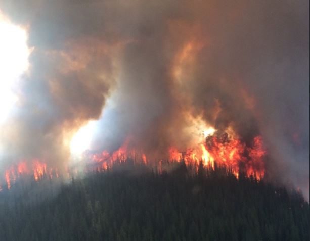
On Friday, the Regional District of the Okanagan-Similkameen issued the alert for the Cool Creek wildfire, which exploded in size overnight. On Thursday, it was estimated at 100 hectares, though there were other fires nearby. By Friday afternoon, it had merged with two other fires and is now estimated at 6,000 hectares.
“We are doing an aerial assessment and are coming up with a fire assessment,” said B.C. Wildfire Service information spokesperson Nicole Bonnett. “With temperatures increasing and relative humidity decreasing, combined with the wind, it definitely influenced the fire size. But, again, it’s three fires that have become one.”
According to the RDOS, “the evacuation alert follows the Ashnola Forest Service Road to the south and east, and the Lower Similkameen Indian Band, Upper Similkameen Indian Band lands and Sterling Creek Forest Service Road to the north, but does not include private property along Highway 3, nor a portion of Upper Similkameen Indian Band lands identified as Chuchuwayha Indian Reserve 2c.”
Meanwhile, it seems that smoky skies in the Okanagan are slowly lifting. However, oddly, having clear skies may lead to increased fire activity.
“As the smoke is lifting, it is raising the temperatures a little bit,” said B.C. Wildfire Service information officer Marla Catherall. “And then the relative humidity is decreasing, so it does provide conditions that could definitely increase fire behaviour.”
While wildfire smoke may help lower temperatures, Catherall added “it’s also inhibiting us from discovering new fires as well.”
Below is a list of notable fires in the Okanagan, Similkameen and Boundary regions:
OKANAGAN
Mount Gottfriedsen
- Location: Pennask Mountain, near Highway 97C, 24 kilometres west of West Kelowna.
- Size: 633 hectares.
- Cause: Lightning.
- Status: Active. Seventy-seven personnel on site with four pieces of heavy equipment.
- BCWS notes: “Crews have completed the guard around this incident. Crews continue to make good progress with mop up operations. Today’s objectives include improving radio communications on this fire and establishing portable bladder site to provide reliable water delivery system to hose lay already established. Continue with mop up operations.”
Harris Creek Forest Service Road
- Location: 16 kilometres southeast of Lumby.
- Size: 508 hectares.
- Cause: Lightning.
- Status: Active, classified as out of control. Twenty-one personnel on site along with eight pieces of heavy equipment and five helicopters.
- BCWS notes: “Crews will continue ignitions along southeast containment line to tie into spot fire. Crews will patrol ignition lines and mop up where necessary. Crews will prepare for ignition on northeast containment line.”
Sugar Mountain
- Location: Four kilometres east of Sugar Lake.
- Size: 332 hectares.
- Cause: Under investigation.
- Status: Active, classified as out of control. Ten personnel on site, along with five pieces of heavy equipment and five helicopters.
- BCWS notes: “Crews continue to lay hose around the north tip of the fire. The skidder will complete building guard on the northwest flank. Crews will patrol east flank for hot spots. Danger tree fallers will work prior to crew entry.”
Mabel Creek
- Location: Six kilometres east of Mabel Lake.
- Size: 1,861 hectares.
- Cause: Under investigation; suspected lightning caused.
- Status: Active, classified as out of control. Twenty-three personnel on site with five helicopters and eight pieces of heavy equipment. An area restriction order is in place for crown land in the vicinity of Mabel Lake.
- BCWS notes: “This fire has grown to the west past Mabel Creek and has joined with several smaller fires. Seven tree assessors/fallers have been assigned due to a high hazard of danger trees in this area.”
Whip Creek
- Location: Three kilometres south of Mabel Creek wildfire
- Size: 133.6 hectares.
- Cause: Lightning.
- Status: Active.
Juliet Creek
- Location: 47 kilometres southwest of Merritt.
- Size: 868 hectares.
- Cause: Lightning.
- Status: Active. Forty-seven personnel on site along with 13 pieces of heavy equipment. Air support available as needed.
- BCWS notes: “Today crews will continue hose lay efforts from 7 km on the upper spur road working east. Danger tree assessing and falling to be completed as required. Mop-up efforts south of Michael Lake should be completed by days end today. To support burn operations, crews will continue building hose lay along the fire guard in the Maka drainage area. Air support will be available to support ground crews as needed.”
SIMILKAMEEN
Snowy Mountain
- Location: 14 kilometres south of Keremeos.
- Size: 13,359 hectares.
- Cause: Lightning.
- Status: Active; classified as being held. Eleven personnel on site along with two helicopters. Additional air support available as needed. Crews will continue to work on the fire patrolling and mopping up.
- BCWS notes: “Continue to patrol and action hot spots as required. Continue establishing contingency control lines near Barrington Creek.”
Cool Creek
Location: 35 kilometres West of Keremeos.
Size: 5,000 hectares.
Cause: Lightning.
Status: Active, out of control. No personnel on site.
Crater Mountain
- Location: 17 kilometres northwest of Keremeos.
- Size: 0.30 hectares.
- Cause: Lightning.
Old Tom Creek
- Location: Seven kilometres west of Olalla.
- Size: 144 hectares.
- Cause: Lightning.
- Status: Active, out of control. 40 personnel on site with 10 pieces of heavy equipment.
- BCWS notes: “Ground crews, heavy equipment and air tankers have been utilised to create new containment lines or tie into natural lines, roads and retardant drops. Crews have made good progress and are conducting small scale hand ignitions to remove fuel between the fire and control lines. Today, crews will focus on continuing to build containment lines and consolidate existing lines.”
BOUNDARY
Lynch Creek
- Location: 25 kilometres north of Grand Forks.
- Size: 161 hectares.
- Cause: Under investigation.
- Status: Active; zero per cent contained. Fifty-three personnel on site with two helicopters and eight pieces of heavy equipment.
- BCWS notes: “Good progress has been made with containment lines on the south flank of this fire. Crews continue to work on containment on the northwest flank of this fire with the support of heavy equipment and bucketing helicopters.”
Toronto Creek
- Location: 16 kilometres north of Grand Forks.
- Size: 11 hectares.
- Cause: Lightning.
- Status: Active; 70 per cent contained. Five personnel on site with one helicopter and one piece of heavy equipment.
- BCWS notes: “The remainder of this fire is burning in steep and difficult terrain. Crews are putting a line of hose on this section of fire.”
Bulldog Mountain
- Location: 32 kilometres northwest of Castlegar.
- Size: 605 hectares.
- Cause: Lightning.
- Status: Active. Four personnel on site, along with two pieces of heavy equipment.
- BCWS notes: “An area restriction is in effect for the area within the boundary of Dog Creek, Grass Creek, Bulldog Eight Forest Service Road and the height of land connecting the noted perimeters.”
Horns Mountain
- Location: Washington state, 400 metres from the B.C. border, 13 kilometres southeast of Christina Lake. On Thursday, it was 800 metres from the border.
- Size: 1,293 acres (523 hectares).
- Cause: Lightning.
- Status: Active, 15 per cent contained. Four hundred and 50 personnel on site.
- USFS notes: “The plan is to construct direct and indirect lines using dozers and other heavy equipment along with hand crews along the western, southern and eastern flanks.”
Comments